
Two useful ideas, sometimes used loosely
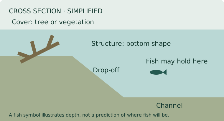
Anglers often use structure for the shape of the bottom: a point, channel, hump, slope or drop. Cover commonly means objects or vegetation that provide concealment or shelter: timber, grass, rocks or a dock. Usage is not universal; agencies may also call placed habitat objects “structures.” Learn what a speaker means rather than arguing over a label.
A fallen tree on a flat bank and a channel edge without trees present different questions. The first is visible cover; the second is a bottom feature that may be difficult to see from shore. A productive-looking photograph does not tell you the water depth, fish depth or whether you may legally access it.
Start with the edge you can actually fish
Look for a defined change you can investigate with controlled casts: the outside of vegetation, the end of timber, a shade boundary or a change in bottom slope. Select a presentation whose depth and hook arrangement suit that area. Do not assume an exposed treble-hook lure and a weedless soft-plastic rig move through cover in the same way.
Begin with the reachable edge rather than sending tackle into the densest obstruction. If you cannot retrieve a cast without pulling across branches or another angler's line, change the angle or choose a different presentation. Respect marked boundaries and private facilities even when fish may be present.
Separate water depth from working depth
A lake can be deep while fish use a shallower layer, and shallow cover can sit beside deeper water. Ask where your lure travels, not just how deep the waterbody is. A lure that passes above the feature is testing a different area from one worked near its base.
For an independent outing, use a small comparison: fish the outside edge, then another reachable layer, and note contact or snagging. Change one factor at a time. Our lure families and freshwater rigs help explain the available tools without pretending one rig is always right.
Habitat is not a guarantee
Texas Parks and Wildlife's habitat information illustrates how different materials create cover and spaces for fish. It is a habitat reference, not a Louisiana location list or a guarantee that a particular brush pile contains a target today. Seasonal conditions, food, water quality and disturbance can change how a feature is used.
Avoid buying electronics on the assumption that an image will identify every fish. First understand the distinction between bottom shape, objects and a return that needs interpretation. A useful search plan can begin with visible edges from verified bank access.
Take the lesson to Louisiana water
For lakes, pair this lesson with bass, crappie or Caddo Lake. For moving water, add current seams. Record what your presentation actually did, and recheck access and conditions on each outing. Learning the feature helps organize fishing choices; it does not establish safe boating or permission to fish a dock.